Map of Malaga Province
The map of Malaga province reveals one of the most captivating regions in southern Spain: 200 kilometres of Mediterranean coastline, white villages (pueblos blancos) nestled in the mountains, and an interior rich in history and unspoilt nature. From the vibrant heart of Malaga city to the remotest corners of the Axarquia or the Serrania de Ronda, this map is your ideal companion for planning an unforgettable route.
Malaga appears on the map of Malaga as a cosmopolitan coastal city constantly evolving. The port of Malaga links the city with cruise ships and ferries to Melilla, making it the perfect starting point to explore the entire province. On the map of Malaga and its villages, you can clearly see how the province of Malaga unites the world-famous Costa del Sol with the authentic Andalusian interior.
Hiring a car is the most comfortable and flexible way to navigate the map of Malaga province. The roads are well signposted, allowing you to travel from the beaches of Marbella to the dramatic gorges of Ronda or the walking trails of El Torcal de Antequera in a single day.
Detailed Map of Malaga Province
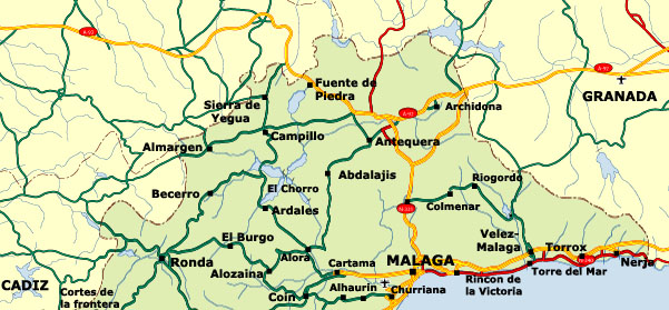
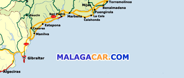
Simply copy the following HTML code with one click:
<a href="https://www.malagacar.com/maps/malaga/">
  <img src="https://www.malagacar.com/maps/images/malaga_map1.jpg" border="0" alt="map malaga north">
  <img src="https://www.malagacar.com/maps/images/malaga_map2.jpg" border="0" alt="map malaga south"><br>
  Map of Malaga province © www.malagacar.com
</a>
The Most Picturesque and Popular Villages on the Malaga Map
The map of Malaga and its villages is dotted with genuine gems: the famous white villages with their dazzling whitewashed houses. Here is a selection of the most beautiful and frequently visited spots, perfect for including in your itinerary:

Frigiliana
Regarded as one of the most beautiful villages in Spain. Narrow cobbled streets, whitewashed houses, and panoramic views over the Axarquia. Just 50 minutes from Malaga city.

Mijas Pueblo
The classic white village with donkey taxis, squares bursting with bougainvillea, and stunning views across the Costa del Sol. Ideal for a morning or afternoon visit.

Ronda
The city of the gorge. The famous Puente Nuevo bridge, Spain's oldest bullring, and dramatic landscapes. About 1 hour and 20 minutes via the scenic A-397.

Casares
A spectacular 'hanging' white village on a hillside – one of the most photographed in the Serrania de Ronda and birthplace of Blas Infante.

Nerja
Famous for its caves and the Balcon de Europa. Spectacular beaches and a genuine seafaring atmosphere at the eastern end of the Costa del Sol.

Antequera
“The heart of Andalucia”. Dolmens (UNESCO World Heritage), a Moorish Alcazaba, and the impressive El Torcal natural site just 5 km away.
Other villages well worth a stop: Genalguacil (the artists' village), Alora, Ojen, and Gaucin.
Essential Natural Areas on the Malaga Province Map
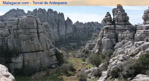
El Torcal de Antequera
A unique karst landscape, one of Europe's most spectacular. Easy walking paths, breathtaking viewpoints, free parking, and a visitor centre.
Sierra de las Nieves (Biosphere Reserve)
Ancient Spanish firs (pinsapos), charming villages such as Yunquera and Tolox, and the famous 'La Escribana' pinsapo tree.
Sierras de Tejeda, Almijara y Alhama Natural Park
Peaks over 2,000 metres, deep ravines, caves, and the dramatic Boquete de Zafarraya. Perfect for hiking and spotting vultures.
Malaga Mountains (Montes de Malaga)
Only 20 minutes from the city. Pine forests, walking routes, and the renowned sweet wines of Malaga.
Getting Around Malaga Province: Your Practical Transport Guide
With the map of Malaga province in hand, hiring a car offers the best way to enjoy complete freedom. Distances from Malaga Airport (AGP) are manageable, and the roads are excellent.

Car Hire: Total Freedom
Pick up your car straight at Malaga Airport and explore the whole province without fixed schedules. Perfect for combining Frigiliana and Nerja in one day or wandering through the Serrania de Ronda.
Hire a car in Malaga
Private Transfer or Taxi: Relaxed Arrival
Stress-free from the airport directly to your hotel or first village. Especially convenient when travelling with family or lots of luggage.
Book transferOther Transport Options
- Intercity buses (ALSA) connecting all villages.
- Local trains Malaga–Fuengirola and Malaga–Alora.
- AVE high-speed train from Madrid to Malaga in under 2.5 hours.
With a good map of Malaga province and a hire car, you can discover hidden corners that organised tours never reach. Your adventure starts here!